Washington, DC, USA
August 9, 2013
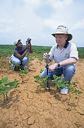
ARS hydrologist Tom Jackson and student Parmecia Jones use different methods to test soil moisture. The measurements will be compared to see which more accurately validates data obtained via satellites. Photo by Stephen Ausmus.
Researchers at the U.S. Department of Agriculture (USDA) may have their feet on the ground, but they're also the go-to experts when it comes to interpreting data from space.
In 2002, Agricultural Research Service (ARS) scientists established soil moisture monitoring networks in four long-term experimental watersheds to verify the accuracy of soil moisture data collected by satellites orbiting Earth. Since then, the ARS researchers have been continuously monitoring soil moisture levels in these watersheds every hour. As a result, they had a vast amount of data they could use to validate soil moisture data collected by a new Earth-orbiting satellite launched by the European Space Agency as part of its Soil Moisture and Ocean Salinity (SMOS) mission.
ARS is USDA's chief intramural scientific research agency, and this work supports the USDA priority of responding to global climate change.
The new SMOS satellite used an innovative sensor technology to estimate soil moisture levels to within 4 percent, which is like measuring a teaspoon of water mixed into a handful of dry soil. But the accuracy of the data needed to be verified with actual soil moisture measurements.
An ARS research team led by hydrologist Tom Jackson compared a year's worth of soil moisture data collected by SMOS with data from the four ARS watersheds, and with data from another satellite system. Jackson works at the ARS Hydrology and Remote Sensing Laboratory in Beltsville, Md.
The scientists determined that the SMOS soil moisture estimates approached a 95 percent rate of accuracy. They also identified conditions that reduced the accuracy of their estimates, such as fluctuations in daily weather conditions, and devised a method for flagging and adjusting these data to improve the accuracy of the resulting soil moisture estimates.
Results from this project were published in 2012 in IEEE Transactions on Geoscience and Remote Sensing.
Read more about this research in the August 2013 issue of Agricultural Research magazine.
Científicos verifican los datos provistos por satélites sobre la humedad del suelo
Investigadores con el Servicio de Investigación Agrícola (ARS) están expertos en interpretar los datos provistos por satélites sobre los niveles de humedad en el suelo.
En el 2002, los científicos del ARS establecieron redes para monitorear la humedad del suelo en cuatro cuencas hidrográficas experimentales para verificar la precisión de los datos provistos por los satélites en el espacio.
Desde entonces, los investigadores han monitoreado los niveles de la humedad del suelo en estas cuencas cada hora. Como resultado, ellos tuvieron una cantidad grande de datos que puede ser usada para validar los datos de humedad del suelo colectados por un nuevo satélite lanzado por la Agencia Europea de Espacio como parte de su misión de Humedad del Suelo y Salinidad del Océano (conocido como el satélite SMOS).
ARS es la agencia principal de investigaciones científicas del Departamento de Agricultura de EE.UU. (USDA por sus siglas en inglés), y esta investigación apoya la prioridad del USDA de responder al cambio climático global.
El satélite SMOS uso una tecnología innovadora de sensores para calcular los niveles de humedad del suelo hasta una tasa de precisión del 4 por ciento, la cual es igual de medir una cucharilla de agua en un puñado de suelo seco. Pero es necesario verificar la precisión de los datos con medidas verdaderas de la humedad del suelo.
Un grupo dirigido por hidrólogo Tom Jackson comparó los datos recopilados durante un año por el satélite SMOS con los datos sobre la humedad del suelo en las cuatro cuencas hidrográficas, y con datos provistos por otro sistema de satélites. Jackson trabaja en el Laboratorio de Hidrología y el Sensoriamento Remoto mantenido por el ARS en Beltsville, Maryland.
Los científicos determinaron que los datos provistos por el satélite SMOS tuvieron una tasa de precisión de aproximadamente 95 por ciento. También identificaron condiciones que redujeron la precisión de sus calculaciones, tales como fluctuaciones en las condiciones diarias del tiempo, y desarrollaron un método para identificar y ajustar estos datos para mejorar la precisión de las calculaciones sobre la humedad del suelo.
Los resultados de esta investigación fueron publicados en 'IEEE Transactions on Geoscience and Remote Sensing' (Actos de IEEE sobre Geociencia y el Sensoriamento Remoto).